
news
J. R. R. Tolkien Annotated Map of Middle-Earth Discovered
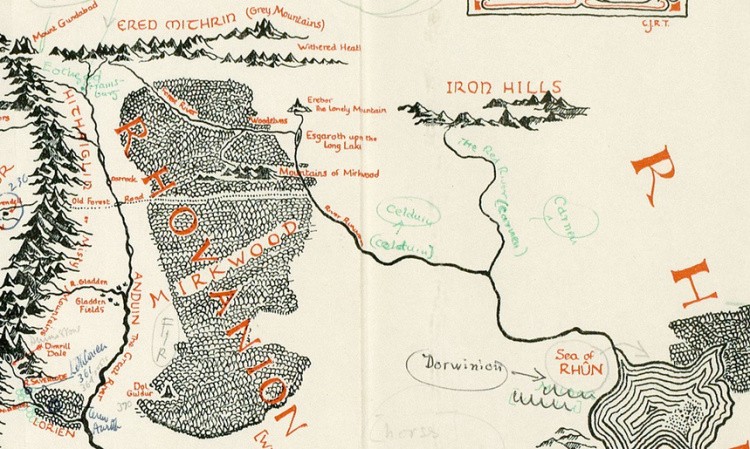
A Tolkien annotated map of Middle-earth was recently discovered when Blackwell’s Rare Books acquired acclaimed illustrator Pauline Baynes’ copy of Lord of the Rings. The map was used by Baynes when she began work on her own color map of Middle-earth, and was found loose in her book, full of annotations by Tolkien.
The map reveals just how particular Tolkien was in his vision, with details on how Hobbiton is at the same latitude as Oxford, and that Minas Tirith was inspired by the Italian city Ravenna, the capital of the Western Roman Empire in the 5th Century.
Pauline Baynes is known for her work illustrating the Narnia books for C.S. Lewis as well as her close collaboration with Tolkien. Correspondence between Baynes and Tolkien indicates that Tolkien’s vision sometimes made him difficult to work with, however it seems that once the illustrations were finished, Tolkien was very happy with them.
Henry Gott, modern first editions specialist at Blackwell’s Rare Books, explains that discovering just how involved Tolkien was in these illustrations is the most exciting part of finding this annotated map, saying: “The degree to which it is properly collaborative was not previously apparent, and couldn’t be without a document like this. Its importance is mostly to do with the insight it gives into that process.”
Blackwell’s is planning on featuring the map in their next catalogue, and is selling the annotated map for £60,000, among other works by Baynes. Baynes passed away in 2008.

Image via Blackwell’s Rare Books